 Google Customer Reviews

In this Blog our Front of House Legend Levi takes us through his end of year bikepacking trip (that sound’s pretty harrowing if we’re being honest). Enjoy!
‘ An adventure that fell perfectly into place ‘
It’s the joy of plans coming together. An invitation to a Mountain Biking / New Years trip at Thredbo Mountain Resort. My friend Rachel being happy to transport my mountain bike there. The big boss Keir telling me I had an unexpected two week break over the Christmas period. Along with my bike being freshly serviced with a new cassette, chain and front chainring.
Everything just seemed to be falling into place and I had no excuses not to plan a trip.
So commenced the planning stage of the adventure, I had a few goals in mind. To ride the Dargo High Plains, spend a night at one of the huts in the Kosciuszko national park, cross another rail trail off my list and finally ride the rugged and remote Barry Way on my return into Victoria.
Countless RidewithGPS routes were looked through, past HUNT1000 routes examined and friends questioned on their past adventures through the Australian Alpine region.
This inevitably led to the creation of my route, linked here over two parts in ridewithGPS – part 1, and part 2.
Day 1- Departure Day
The plan was set, bike packed and food loaded. Now all I had to do was ride.
A 4:30am wake up on boxing day, a dark ride to Hawthorn station for the 5:40am train to Lilydale. I’ve ridden out of Melbourne’s suburbs countless times and find it rather unenjoyable nowadays, with there being no current way to reach Lilydale on only bike paths.
Lilydale hosts the beginning of the famous rail trail to Warburton, passing through the towns of Mount Evelyn & Sevilla, 40kms in length and a rather easy ride along the gravel with no major hills to climb. But still a wonderful ride and one I highly recommend for anyone wanting to escape Melbourne for a day.
The quaint town of Noojee was my next stop, nestled in the middle of a valley and at the base of what was to be quite a climb coming out of it. A big meal was required to energise me and the local café had the goods. A serve of their finest Fish n Chips, which was so big even I struggled to get it all down! With a full belly I continued upwards with the days goal being to make it to Woods Point and camp along the Goulburn River. But then came the mist, which inevitably led to the start of the days forecasted rain. This would follow me for the next few hours.
I started having my first spates of “I could just pull over there and set up camp”. But nevertheless, I continued, meeting an unexpected crustacean in the middle of the road, with some investigating I believe it to be an ‘Engaeus hemicirratus’.
The rain continued as I made my way through the old mining areas on the Warburton – Woods Point Road, eventually reaching the tiny town of Matlock. It was here, soaking wet and sunset just moments away, I decided to call it for the day. Whilst Woods Point was only 5kms away (all being downhill) I had shelter here in Matlock under the small picnic area, the first shelter I’d had since leaving Noojee. With my bed set up for the night, I enjoyed a 3-course meal consisting of a 4-cheese soup with croutons, tuna with black beans and a dessert of chocolate covered sultanas. It was then lights out to the sound of the rain on the roof of the picnic shelter.
Day 1 Stats –
163.41kms
3,245 meters gained
10 hours 45 minutes moving time.
Song of the day – Djorolen by Oumou Sangare


Day 2
I awoke to the magpies singing away, fog covering the entire town of Matlock and NO rain!! Well at least no rain for the next few hours. A quick instant mocha and some oats and I was back riding at around 6:30am.
The mornings riding consisting of undulating gravel roads before hitting the bitumen on the Licola – Jamieson Road. The descent into Licola was super fun, not a car in sight and beautiful roads to pick up some speed on. I’m talking like 14kms in around 22 minutes, which is FAST compared to the usual riding you endure when burdened with gear and wide tyres.
Whilst these roads are fun you’ve always got that voice in the back of your mind… You’ve got to climb back up this elevation at some point.
Licola had the most activity of anywhere I’d ridden since leaving Lilydale. The caravan park was full and hordes of 4-wheel drive crews passed through, refuelling and on their adventures.
For my own refuelling it consisted of a sausage roll, veggie pastie and quite a few lollies before I too set off again, following along the Wellington River.
The Tamboritha road was a highlight of my trip, with some 13 campgrounds dispersed along the Wellington River, most with facilities and pristine river frontage. To my surprise, many of these campsites were empty during the Christmas holidays! It’s also all paved, making it accessible without a 4WD!
Soon after passing the final campsite, the road turns back to gravel, with clearly marked signs warning those in 2WDs that the roads aren’t going to be so kind anymore.
It also meant the beginning of the climb into the Alpine National Park, where conditions can change in a heartbeat, and they sure did. The rain commenced soon after I hit the gravel and didn’t stop till the early hours of the next day.
Once the rain begins, the questions also begin inside your head. Where was I going to end? Well, I didn’t really know, there were a few huts along the trail that I’d pinpointed, so I’d just shoot for one of those.
A few hours of climbing in the rain later, the signs for the Horse Yard Flats Hut appeared along the Moroka Road. Saturated from head to toe in a rich red coloured mud, I was very excited to shelter in the hut and get myself cleaned up and dry.
There wasn’t anyone else around, except for the dead rats and small birds within the hut, making it by far one of the darkest and eeriest feeling huts I’d ever stayed in. But still, that’s better than the rain, right?
Day 2 Stats –
141km
2,853 meters gained
9 hours 22 minutes moving time
Song of the day – Eye in the Sky by The Alan Parsons Project.


Day 3
Day 3 commenced with another early morning wake up, oats ‘n’ coffee, before I got back onto my crunchy sounding bike. Filled with fine little bits of sand and grit all through the drivetrain – this was after I’d given it a good clean! The weather was finally on my side and the rain had subsided, perfect conditions as I was headed to the most dangerous part of the entire trip.
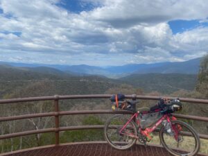
Just a few kilometres into the days riding, I stood at 1350m atop the Billy Goat Bluff. Clouds ran parallel around, blocking out the blue skies to those down below. I had a 1150-meter descent to endure, with gradients of over 30% in some sections. Whilst not impossible to ride, with food, gear, and everything else attached to my bag, I didn’t see the risk = reward, so decided to walk some of the 7km section ahead.
Even that was a challenge, just walking down this road was hard enough, let alone with a 20-something kilogram bike carrying all your possessions. So, with white knuckles clenching my brakes I managed my way down the Billy Goat Bluff to the Wonnangatta River and Road.
The sun was shining as I road along the Wonnangatta, my first time in the area, such pristine waterways, another hidden gem to put into my collection. The next stop was going to be the famous town of Dargo, a must visit for any 4WD exploring Victoria’s high country.
I wasn’t disappointed with an array of the usual; 79 series Land cruisers, Patrols, Pajero’s and the newer American rigs from RAM, Chevrolet and Ford. They were all lined up getting their photo with the famous pub in the background. Oh and don’t forget the sticker for the rear window on the way out.
I sat opposite the pub, enjoyed a burger with the lot and a vanilla milkshake whilst watching what’s normally a quiet country town, now bursting with 4WDs.
It was then time to complete my first goal of the trip, riding the Dargo High Plains. But there was that voice in the back of my mind again… “You’re only at 200m elevation right now, you need to be at 1600m……fabulous”.
So began the slog of a climb up to the Dargo High Plains. Don’t get me wrong, I love climbing, but this one really made me suffer. With the gradient hovering around 8-10% for most of the first 20kms. The heat had increased, and I was quickly wishing for the rain to return, but to no avail.
After a few hours of riding, majority uphill, the real beauty of this road emerged; the white branches of the dead snow gums littering the mountains, like skeletons fingers poking through the soil. The long grasses of the high plains moving in unison with the wind, like a group of ghosts dancing. The Dargo High plains lived up to its reputation and I’m glad my first time here was on a bike, allowing me to take in just how stunning of a place it is.
The day finished nearly atop Mt Hotham, but at Blowhard Hut, overlooking the valley down below where I once lived. A sunset all to myself, and a bloody beautiful one at that. The days hardships seemed all worth it when I could sit atop there eating my baked beans.
Day 3 stats –
128.8km
3,514 meters gained (most ever in my life)
9 hours 42 minutes moving time
Album of the day – Bad Brains self-titled album – Bad Brains.


Day 4
I awoke to an incredible sunrise looking over the valleys surrounding Mt. Hotham. I started my ride early to avoid as much of the traffic whilst crossing over Mt Hotham and Dinner Plain.
Luckily, I’d done the hard yards the day prior and could soak in the views riding on my way down to Omeo.
It was rather uneventful, although I did spot my first bikepackers of the trip as I flew down the backside of Dinner Plain, beginning their days ride up the 1000+ meter climb.
After a delicious pie and 2 Big M’s in Omeo I continued along the Omeo Highway to Benambra, where I had a lovely chat to a group of locals, ate some delicious plums growing next to the general store and gathered the last supplies I’d need for the day.
I continued along Limestone Road for 45kms before reaching the turnoff for the Cowombat Track. The beginning of Cobberas Wilderness Zone, with access restricted to only bikes and hikers.
Soon after starting I connected with the Australian Alps Walking Track. This trail was certainly not built with bikes in mind, with a few steep loose sections resulting in some hike-a-bike.
I had my eyes set on making it to Charlie Carter’s Hut that evening, so passed on the opportunity to stay at a lovely campground just on the border of Victoria and NSW, as the Kosciuszko National Park starts. This is also the location of Royal Australian Air Force Plane – ‘Dakota’ an A65-50 that had crashed in 1954; not what I was expecting to find strewn about in the middle of the National Park.
With sunset fast approaching I continued.
Tonight I wanted to achieve a goal I’d set out from the beginning – stay a night in a hut in the Kosciuszko National Park.
I looked over my route and had found Charlie Carter’s to be an achievable distance away. Riding during the golden hour was magical, sun bursting through every crack amongst the tress, the sky looking as if it’d been drawn using a pastel colour palette. With the daylight just about depleted, it was as if the whole bush had suddenly come to life, with brumbies and dear appearing around me. I rode along, startling these large animals, hearing them gallop and scatter away from me and the light shining from my bike.
Just on 9pm I arrived at Charlie Carters, a fire raging out the front and the sounds of world music beats in the background. I met two lovely hikers there, out exploring the beautiful National Park like me. Instantly I was offered Fireball and chocolate, not what I was expecting when I arrived, exhausted from a day of riding in the sun.
It’s interactions like this that I love about the outdoors and the community that enjoy the outdoors. People let their guard down when they’re in a new environment. Someone you’d normally pass by with no second thought becomes your best friend for the evening. Sharing tales of the journey you’ve had that day or during your trip. It’s these bonds, with a crackling fire in the background, that I find myself at peace with the world. It’s human interaction at its most basic and an interaction that’s been shared by generations of human beings before me and hopefully one that can be enjoyed well into the future.
After some two hours of chatting, I called it a day. Ending a perfect day of riding, starting with a glorious sunrise over Mt Hotham and finishing around the campfire in the Kosciuszko National Park.
Day 4 stats –
162.04kms
3,403 meters gained
10 hours 50 minutes moving time
Song of the day – Lunge Forward – Wavves


Day 5
Another incredible sunrise over Charlie Carter and the Mining Hut before heading out on the last section of my ride just after 7am.
Some of the most picturesque riding I’d done on the whole trip so far, the Cascade trail was utterly breath-taking.
I met quite a few hikers and bike riders along this section, most out for day trips on a beautiful Saturday morning.
Quick conversations are had, most just appreciating how lucky we all are to be amongst the National Park with such spectacular weather.
A benefit of having had a lot of rain up until this point mean that everything was a lush green, brimming with life from the small insects to the brumbies galloping around.
Pictures can never do a place like this justice. The sun beating down on your body, the smell of fresh mountain air, the breeze against your face. This is truly my happy place amongst nature.
Just 25kms into my days riding I came to the end of the Cascade Trail and the start of the tarmac. A busy trailhead with eagerly excited outdoor enthusiasts ready to start their days adventures.
The ride was downhill, picking up some serious speed as I went, to my left was the Thredbo Mountain Resort and Mt Kosciuszko (Australia’s tallest peak) behind it.
Having not been surrounded by many people, arriving at Thredbo was a little shock – summer holiday makers everywhere! Some going fly-fishing others to hike and majority of them with bikes on the back of their cars!
I looked over my directions and continued heading downhill on the Thredbo Valley Trail. A well-constructed trail that follows along the Thredbo River. Consisting of bridge crossings and some fun single track to rip on with the gravel bike.
Some 12kms later I had arrived at my destination – the Ngargio Campsite. After 4 and a half days, I had ridden a total of 640kms, climbed 14,000 meters and was ready to jump into the Thredbo River to clean the stench off me!
It was here at the Ngargio Campground that I would meet my friend Rachel and a whole new group of friends, all with a similar interest… mountain biking.
But the bikepacking trip wasn’t finished here, I still had to get home!
Day 5 stats –
41.27kms
1,062 meters gained
3 hours 33 minutes moving time
Song of the day – None, I just rode to the noises around me


‘Day 6 – The bad weather Begins’
You know the weather isn’t looking good when everyone in the campground leaves early… that’s exactly what was happening at the Ngargio Campground.
All the crew I’d been mountain biking with had decided to leave the day before and it was just Rachel and I left on the Wednesday morning. We said our farewells – Rachel kindly taking my mountain bike back to Melbourne and any other gear I deemed unworthy of carrying the rest of the way home.
I set out from the campground at 7:15am, beginning the most eventful day I’ve ever had on a bike.
The plan was to ride from Ngargio Campground to McKillops Bridge via the Barry Way. Having driven along the Barry Way in 2022, I’d found myself wanting to return and enjoy the remote road through to Victoria at a slower pace than in a car.
I was excited to be able to look around rather than concentrating on the road – if you’ve driven the Barry Way, you’ll understand some sections are sketchy!
I continued down the Alpine Way until I reached Crackenback – from here I headed towards the Wollondibby Fire Trail, cutting off the need to go down to Jindabyne and then back up on the beginning sections of the Barry Way.
This saved me a fair chunk of time and the risk of being on the major highway with holidaying vehicles!
As I climbed along the Wollondibby Fire Trail, I did end up going through private property for a small section before reaching Big Yard Road. So, if you are following my route, take note that I’m not 100% if I should have ridden through here. Multiple routes I’d found on Strava – RidewithGPS and even Google Maps told me people had been riding through here previously.
I risked it and rode the very loose rocky downhill fire trail to the Big Yard Road, crossing the Mowamba River, which was waist high from all the rain! It was then a few kilometres, and I was on the Barry Way!
This section of the Barry Way runs alongside farming land until you reach the Kosciuszko National Park.
There’s an incredible lookout that I decided to stop at and enjoy an early lunch, already 60kms into my ride. While sitting here I had a police 4WD pull up next to me, the officer had just been down near the Victorian border checking over a car accident from the night before; a vehicle had gone over the edge. Not an unusual incident for this notorious road – with many cars still laying at the bottom of the gorges, unable to be retrieved after crashing. The road’s many blind corners, unpredictable surfaces and Google Maps desire to send everyone it possibly can along the road, lead to many incidents!
But my gosh is it stunning and totally worth all the risks! The ride downhill from the lookout was spectacular, I kept having to stop and try to capture the scenery. A phone will just never do a place like this justice.
After a good 15kms of downhill I began to cycle along the Snowy River, it was peeking through the gum trees lining the road. Multiple campgrounds start to pop up along the way and I continued to find myself stopping and admiring the river.
At around 12:30pm I had the first shift in weather for the day; dark clouds emerged and a 30 minute downpour started.
I have a lot of appreciation for the crew who maintain the road. The drainage system is incredible, with so much rain coming down the entire road would flood, waterfalls would appear along the sides and gushing streams on either side of the road. But within a matter of 15 minutes all the water would be gone, leaving the road almost untouched.
This would occur for several hours; I had just passed Suggan Buggan at around 3:30pm and started the climb upwards to Black Mountain when the major rain clouds came through.
I’m talking some serious rain clouds, the entire sky was black, as if the sun had set, the wind changed, and I knew I was in for some serious weather. There isn’t much you can do when you’re on your bike in an area like this, sheltering under a tree just worsens the chances of something happening.
I put my rain jacket on, ensured my electronics where secured and watertight and continued to ride.
The rain didn’t hold back, pouring down and quickly erupting all over the road, like the flash floods that had occurred throughout the afternoon… only worse.
The first hailstone hitting my helmet scared the bejesus out of me and quickly I was under attack, hailstones the size of grapes pounding down. This is also the section of the climb when you are most exposed, the road has been cut out of the side of a mountain. With an unguarded cliff edge to my left and steep rock face on my right, water poured all along the road.
To my shock this is also when I came across another bikepacker, barely able to look up under the hood of my rain jacket I saw him approach around the corner. We both screeched to a halt, eyes wide and instantly exclaimed to one another ‘what the fuck are we doing here!?!’.
My first interaction with another bikepacker for the entire trip and it was here of all places, with rain pouring down around us, questioning why we were doing this to ourselves.
After a small chat, asking where each of us had started/ending we said our farewells, exclaiming that we were glad to have met someone else experience the hardships we were both going through.
Type 2 fun is always better with someone else.
I continued climbing, eventually reaching the tarmac as I made my way to Black Mountain, the rain had stopped but now the aftermath of all the rain could be seen. From a vantage point you could see all the water pouring down the hills and into the stream, the roads themselves still flooded with water. I rode through one section that was higher than my front chainring and finally was able to document some of the flooding.
It was now 4:40pm, I was 120kms in, soaking wet down to my underwear, rain was forecast to continue through till the next day and I knew there wasn’t any decent shelter at McKillop’s Bridge (this was my initial target for the day).
I decided to take it upon myself and ride to Buchan, an additional 35kms of riding, but if I made it before 8pm I’d be treated with a warm pub meal.
I put my head down and rode hard for 3 hours, passing the turn off for McKillop’s bridge and the locality of Gelantipy.
Arriving at the township of Buchan with 15 minutes to spare, only to be met with a kitchen closed sign… but after some charming was able to get a burger with the lot and a cold pint!
I had a few of the patrons approach me, asking about my day’s travels, some even questioned if I was the same person they’d passed earlier in the day at the beginning of the Barry Way!
After devouring the burger, I found myself unsure on where I’d spend the evening, with the campground at the famous Buchan Caves closed due to a recent tragedy on Boxing Day involving flash flooding.
After a discussion with the publican, I rode over to the towns football oval and pitched my tent behind the field bench. Ready for a good nights rest after the craziest day I’d ever had bikepacking.
Day 6 Stats –
Distance: 186.05kms
3256 meters gained
10 hours 28 minutes moving time
Song of the day – An Honest Mistake – The Bravery


Day 7 – Final Day
I awoke to more rain, it had come in ebbs and flows all evening and continued well into the early afternoon. My plan was to ride the East Gippsland Rail Trail, with Nowa Nowa my entry point.
Motivation was low and camping spots didn’t look plentiful around the Bairnsdale area (yes there’s caravan parks, but I prefer not to pay for my campsites).
So prior to leaving from Buchan, I booked a train ticket for that evening back to Melbourne. I’d originally wanted to make it back to Warrigal, but after the previous days ordeal couldn’t bring myself to spend another 2 days camping in the wet.
I left Buchan along the main road, quickly ducking off into the State Park and the gravel fire trails.
20kms later I had reached the East Gippsland Rail Trail and Nowa Nowa shortly after. A fresh muffin and Big M from the general store got the spirits up and I put my head down and continued riding.
The kilometres accumulated rapidly, or at least a lot quicker than previous days! It was just a bit before 12pm when I arrived at Bairnsdale, helping myself to a nice meal at the local fish ‘n; chip shop.
It then occurred to me that I absolutely stunk, I hadn’t washed my clothes in over a week. So I popped into the local op-shops and picked myself up a new outfit for the train ride home! Spending the rest of the afternoon people watching around the train station and drying out my clothes and tent.
Therefore, ending a fantastic week and a bit of riding. Getting the best of both worlds – a solo bikepacking trip with a destination where I could meet friends and enjoy some company for a few days – before heading back on the solo adventure grind.
Day 7 Stats –
Distance: 96.82kms
745 meters gained
4 hours 51 minutes moving time
Song of the day – Shut Em Up – The Prodigy & Public Enemy


